HYPACK 2022 v1.22

HYPACK 2022 v1.22

What is HYPACK?

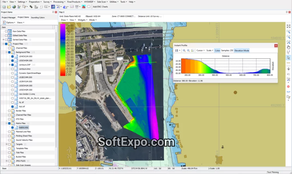
HYPACK is a widely used hydrographic surveying suite that covers planning, real-time acquisition, processing, QC, and final deliverables for single-beam, multibeam, side-scan, sub-bottom, and positioning sensors. It supports hundreds of devices and provides modules for survey design, data cleaning, surface modeling, volume computations, and chart outputs.

Core modules and capabilities

  • HYPACK SURVEY: Project setup, geodesy, background charts, real-time navigation, and acquisition from GPS, echosounders, magnetometers, gyros, and more.
  • HYSWEEP: Multibeam acquisition (parallel to SURVEY), real-time coverage maps, and tools for alignment/calibration with robust multibeam editing and performance checks.
  • DREDGEPACK: Dredge guidance for cutter suction, hopper, excavator, and clamshell operations with position history and production support.
  • Side-scan: Collection, targeting, and mosaicking for analog and digital side-scan; GEOCODER provides mosaics from side-scan, multibeam backscatter, and snippets.
  • Sub-bottom: Acquisition and SEG-Y export for analog/digital sub-bottom systems.
  • CLOUD, MB/Editor: Data review, cleaning, filtering, and multibeam calibration tools for high-quality bathymetry.
  • TIN MODEL: Surface generation, DXF contours, volume computations, and gridded XYZ/BAG exports.
  • ENC EDITOR: Create or edit S-57 ENCs as a standard feature.
HYPACK 2022 v1.22

Typical workflows

  1. Planning and geodesy: Create a project, define projections or local grids, import background layers (S-57, GeoTIFF, DXF/DGN, BSB, VPF), and design lines for coverage goals.
  2. Acquisition: Configure GNSS (e.g., NMEA via UDP/TCP), set offsets, and log single-beam or multibeam data with real-time QC and coverage feedback in SURVEY/HYSWEEP.
  3. Tides/ellipsoid heights: Apply water level corrections (e.g., RTK tide or modeled transformations) to reference the bathymetry consistently.
  4. Processing and editing: Use multibeam editors for automatic/manual filtering, system alignment, and performance testing; leverage CLOUD/MB tools for cleaning.
  5. Deliverables: Build TIN surfaces, compute dredging volumes (by sections or surfaces), export contours, mosaics, XYZ/BAG, or smooth sheets via HYPLOT; edit ENCs if needed.

Key strengths

  • Broad sensor support and integrated workflow—from planning to deliverables—in one ecosystem.
  • Real-time coverage and QC for multibeam with alignment and performance test tools required by agencies like USACE.
  • Strong dredging capabilities and industry-standard volume computations for estimating cut/fill and production metrics.
  • Built-in charting and mosaic tools (ENC editor, GEOCODER) reduce dependence on extra software.

Notable 2024 updates

Recent releases highlight improvements like time-variable height transformations, enhanced line planning (move/rotate), TPU editor, naming conventions, multi-beam workflow refinements (e.g., MB Max 64), and water column playback—aimed at accuracy, efficiency, and data traceability.

Licensing and deployment

HYPACK is available in packages (e.g., HYPACK Lite, MAX, HYSWEEP, DREDGEPACK), with options for office-only or full survey use; organizations often maintain module-specific licenses at scale. Leasing is also available (annual or short-term), including soft license options and upgrade credits toward perpetual licenses.

Free Download – HYPACK 2022 v1.22

Download link

More you can find useful tools in our office and productivity category.

Common use cases

  • Port and channel surveys with multibeam coverage targets (e.g., 100–200%).
  • Pre/post-dredge surveys, production monitoring, and volume calculations.
  • Environmental and habitat mapping using side-scan mosaics and backscatter analysis.
  • Engineering and construction positioning for marine projects.
  • Sub-bottom profiling for geotechnical context with SEG-Y outputs.

Quick setup tips (field-proven)

  • Geodesy first: Lock datum/projection before logging data to avoid re-referencing later.
  • Measure offsets: Enter precise sensor offsets and verify mounting geometry; small errors propagate into depth and footprint.
  • GNSS I/O sanity check: Confirm NMEA sentences (e.g., GGA, ZDA, HDT) rates and network ports; test device data in HYPACK HARDWARE before sailing.
  • Coverage maps: Use HYSWEEP’s coverage to confirm your swath overlap and revisit gaps in real time.
  • Save frequently: Adopt versioned project saves and keep raw data immutable for audit trails.

Alternatives and ecosystem

HYPACK competes with Qinsy, EIVA, and others in hydrographic acquisition; choice depends on project scale, hardware ecosystem, and team familiarity. For topographic/RTK use cases, HYPACK workflows can complement land-survey data where appropriate, but many teams pair with land-focused software in mixed environments.

Summary

HYPACK offers an end-to-end hydrographic solution: robust planning, real-time acquisition, advanced editing, dredging volumes, mosaics, ENC editing, and publication-ready plots—all with broad hardware support and agency-aligned QC features. If you share your project type (e.g., multibeam dredging acceptance, environmental mapping, port chart updates), I can tailor an exact setup and processing checklist for your needs.

Frequently Asked Questions about Free Download HYPACK

1. Is HYPACK free for hydrographic survey use?

HYPACK is commercial hydrographic survey software offered in packages like HYPACK MAX, LITE, OFFICE, SURVEY, HYSWEEP, and DREDGEPACK. Free access may be available through our website.

2. What does HYPACK do in a hydrographic survey workflow?

HYPACK provides end‑to‑end tools for survey planning, real‑time data acquisition, multibeam/single‑beam processing, side‑scan mosaicking, tide and RTK corrections, TIN modeling, volumes for dredging, and deliverables like contours and charts, supporting hundreds of devices for robust hydrographic acquisition and post‑processing.

3. What is HYSWEEP, and how does it relate to multibeam echosounder data?

HYSWEEP is the HYPACK module for multibeam echosounder acquisition and processing, adding capabilities for MBES/backscatter, water column, and LIDAR workflows; it requires a HYPACK license and lets teams upgrade from single‑beam to multibeam within the same hydrographic survey ecosystem.

4. Which industries and use cases benefit most from HYPACK?

Ports and channels, dredging contractors, environmental mapping teams, and engineering firms use HYPACK for multibeam coverage surveys, dredging volume calculations, side‑scan sonar search and mosaics, and ENC/chart outputs within a rigorous geodetic framework for seabed mapping and construction positioning.

5. Does HYPACK support side‑scan sonar and mosaicking?

Yes, HYPACK supports side‑scan data collection and post‑processed mosaics (e.g., GeoTIFF), enabling target marking and hydrographic acquisition workflows that integrate with the broader survey planning and deliverables toolchain for seabed mapping.

6. Can HYPACK work with RTK tides, geodesy, and external data formats?

HYPACK includes comprehensive geodetic tools, supports RTK/ellipsoid‑based tide corrections, and handles background charts and exports such as DXF, BAG/XYZ, and GeoTIFF, streamlining hydrographic survey planning and coordinate system management for accurate bathymetry.

7. How does HYPACK integrate with other hydrographic software or data?

HYPACK supports broad device drivers and interoperable formats; other packages can exchange raw or processed data with HYPACK (e.g., exporting HYPACK‑style raw data records like EC1, POS, and TID) to fit mixed hydrographic acquisition and post‑processing pipelines.

Discussion on HYPACK 2022 v1.22

Tips, Help With Activation, Sharing Cracks